
DAN PROCTER, HISTORY SUBJECT DEVELOPMENT LEAD, TEACH FIRST, UK
STEFAN CARRON, GEOGRAPHY SUBJECT DEVELOPMENT LEAD, TEACH FIRST, UK
Landscapes constantly evolve. At times and in places, this evolution is creeping, barely noticeable, a distant memory, whereas in other circumstances, landscapes are shaped by powerful physical and human processes that alter how that place is experienced and imagined, both in the present and in the future. Geography and history are best placed to uncover this change over time – peeling back the layers of diverse, contested and often under-appreciated landscapes.
Why this matters
In this article, the landscapes of the Lake District have been selected as part of a project called Historic Landscapes to tell a story through time. As highlighted by the Curriculum and Assessment Review (DfEDepartment for Education - a ministerial department responsible for children’s services and education in England, 2025), we live in a rapidly changing world where environmental changes present opportunities and challenges to young people. The pedagogical approach underpinning this work emphasises the centrality of landscapes in human history and demonstrates why their protection matters. Environmental change becomes the organising principle of the narrative, offering a powerful disciplinary bridge. As Lambert (2021) notes, history without geography is ‘groundless’ and geography without history is ‘without context’. The Historic Landscapes project attempts to bring the two disciplines together while still respecting the heritage of each.
How the planning was approached
Stories of human relationships with the natural world that integrate geographical and historical concepts are increasingly highlighted in recent scholarship, including Frankopan’s The Earth Transformed (2023). Inspired by such works, Historic Landscapes treats the physical landscape as a narrative anchor and a historical source. Natural processes and features hold compelling stories from both the past and the present, and projecting these narratives into the future provides pupils with an opportunity to understand their role in environmental change and promoting sustainable practices. The interdisciplinary nature of Historic Landscapes opened opportunities to include a wide and diverse range of sources. As Riley and Kitson (2024) observe, art and literature can reveal much about attitudes to the natural world through time, while at the other end of the spectrum, inserting scientific sources of evidence, such as pollen analysis and ice core samples, can add depth to the story of a landscape.
To ensure that the project can be transferable to any landscape, specific lenses were chosen to build pupil knowledge and understanding (Table 1). Within each ‘landscape of…’ lesson, pupils are encouraged to consider how geographical phenomena impact upon historical events and vice versa. The landscape is no longer a static backdrop but is influential in shaping human behaviour through time. For example, in Lesson 3 (ancient memory), pupils find out that Neolithic people in the Lake District crafted axe heads from a volcanic rock seam found in the Langdale Fells. Pupils then use pollen records to uncover how these axe heads were used to shape the natural environment through deforestation of elm trees to create open land for grazing.
Table 1: How has the Lake District been shaped over time? Sequence of lessons that could be transferred to any landscape
| Landscape of…. | Lesson question |
| (Introduction) | 1: What are the natural wonders of the Lake District? |
| PROCESS | 2: How did natural forces shape the Lake District? |
| ANCIENT MEMORY | 3: How did early settlers shape the Lake District? |
| POWER | 4: How did the Lake District shape and reflect power in Roman and medieval times? |
| MEANING | 5: What were the consequences of the Industrial Revolution for the Lake District? |
| INDUSTRY | 6: How has industry shaped the landscape of the Lake District? |
| CONFLICT (PART 1) | 7: How has protest shaped the way we see the Lake District? |
| CONFLICT (PART 2) | 8: How is the climate crisis causing conflict in the Lake District? |
| HOPE | 9: Is the Lake District being protected for future generations? |
Telling the story of landscape–human interaction
Central to the pedagogy is a unifying enquiry structure that moves chronologically from geology and glaciation to contemporary climate conflict (Table 1). This sequencing functions as a narrative arc. Each lesson revisits and deepens earlier knowledge, helping pupils to grasp the landscape as a palimpsest – continuously reshaped yet retaining the traces of previous eras.
Across the sequence, pupils work directly with the core evidential practices of both geography and history. Geological features (Figure 1), OS maps, climate graphs and ecological datasets sit alongside pollen records, Neolithic artefacts, medieval monastic remains and protest writings by William Wordsworth, Beatrix Potter and Hardwicke Rawnsley (one of the founders of the National Trust). Pupils learn not only what happened, but also how we know. Through interpreting this wide range of sources, they engage in the disciplinary habits that allow pupils to reason about change, causation, continuity and significance.
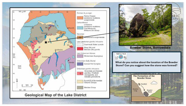
Figure 1: A geological map of the Lake District, highlighting the Bowder Stone
If pupils can see or (better still) know the landscape in question then they are better placed to connect the human story to the physical story over time, grounding complex ideas in places that feel familiar and meaningful. Visual images can transform and enrich how we see and understand places (Geographical Association, nd). Immersive Google Earth panoramas, relief maps, valley cross‑sections (Figure 2), paintings and contemporary images of flooding, erosion and tourism were used to help pupils visualise how the landscape of the Lake District was shaped first by ice, and then by human actions such as farming, mining and later by tourism, and now by climate-driven pressures.
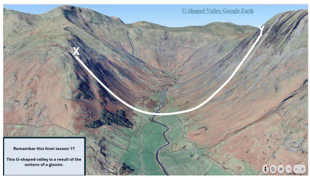
Figure 2: U-shaped valley (Langdale)
A further high‑leverage feature is structured comparative thinking. Pupils analyse how different groups (Romans, monks, industrialists, tourists, farmers, environmentalists) have used, valued or contested the landscape (Figure 3). Tools such as Venn diagrams, stakeholder mapping and consequence chains support the development of analytical writing and evaluative judgement. Pupils compare how power was asserted through forts and then monasteries and castles; how meanings of the landscape shifted with Romanticism and industrialisation; and how climate change intensifies modern conflicts over access, conservation and land use.
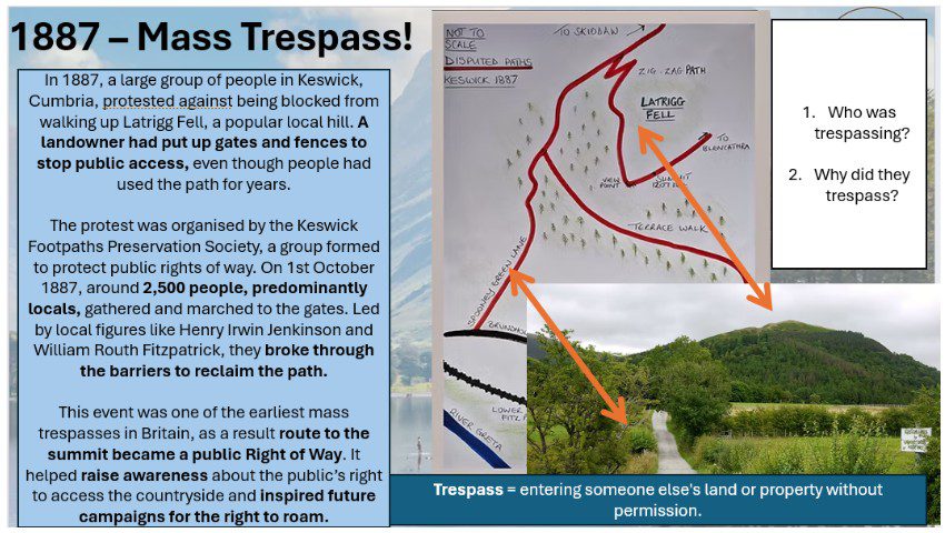
Figure 3: A slide from Lesson 6 on protest
Taken together, these pedagogies create a narratively rich and intellectually rigorous journey. Pupils see the Lake District not as a backdrop, but as an evolving interplay between physical forces, human needs, cultural values and environmental futures.
Teaching challenges
Delivering this sequence requires dedicated curriculum time and either (i) coordinated teaching by both geography and history departments or (ii) implementation within a single subject. This raises practical considerations, such as cross-departmental planning, aligning schemes of learning and supporting teachers to develop secure knowledge in both disciplines.
The sequence has been designed for Year 7 as an introduction to history and geography, providing an overview of the core disciplinary skills in each. It is intentionally adaptable, enabling teachers to tailor content to their context. Additionally, the detailed lesson materials can serve as a professional development resource, supporting subject knowledge enhancement.
Reflection
The choice of landscape for future projects is extensive, and selecting one that illuminates both historical and geographical processes is a key professional decision. This approach offers a flexible interdisciplinary framework that can be applied to any landscape across the UK’s four nations.
UK landscapes are diverse, striking and deeply significant. Exploring local landscapes provides pupils with both a mirror and a window into the national story. This process can foster appreciation of the rich historical and geographical narratives that shape their surroundings, instilling pride and a sense of place. Encouraging pupils to articulate why these landscapes matter and why sustainable practices are essential can help them to recognise their potential as agents of change.
DiversityThe recognition of individual differences in terms of race, ethnicity, gender, sexual orientation, socio-economic status, physical ability, religious beliefs and other differences and representation have been integral to the design of these lessons. It is vital to challenge dominant narratives of ‘belonging’ and ask ‘whose landscape?’. By uncovering hidden stories and highlighting the contributions of diverse groups, we enrich pupils’ understanding of how landscapes have been used and transformed over time.
Finally, while UK landscapes have demonstrated resilience and adaptability, they face increasing pressures. We must act collectively to cultivate a sense of urgency in protecting them. As Hawkey (2023, xvi) reminds us, ‘We ignore the historical roots of our current crisis at our peril’ (2023). This work cannot be achieved in disciplinary silos; moving forward, it demands connectedness between history, geography and beyond.
You can access all the materials discussed above here: https://padlet.com/rqwh8wsdhg/historic-landscapes-bhj0gt8iwxq9gmjq